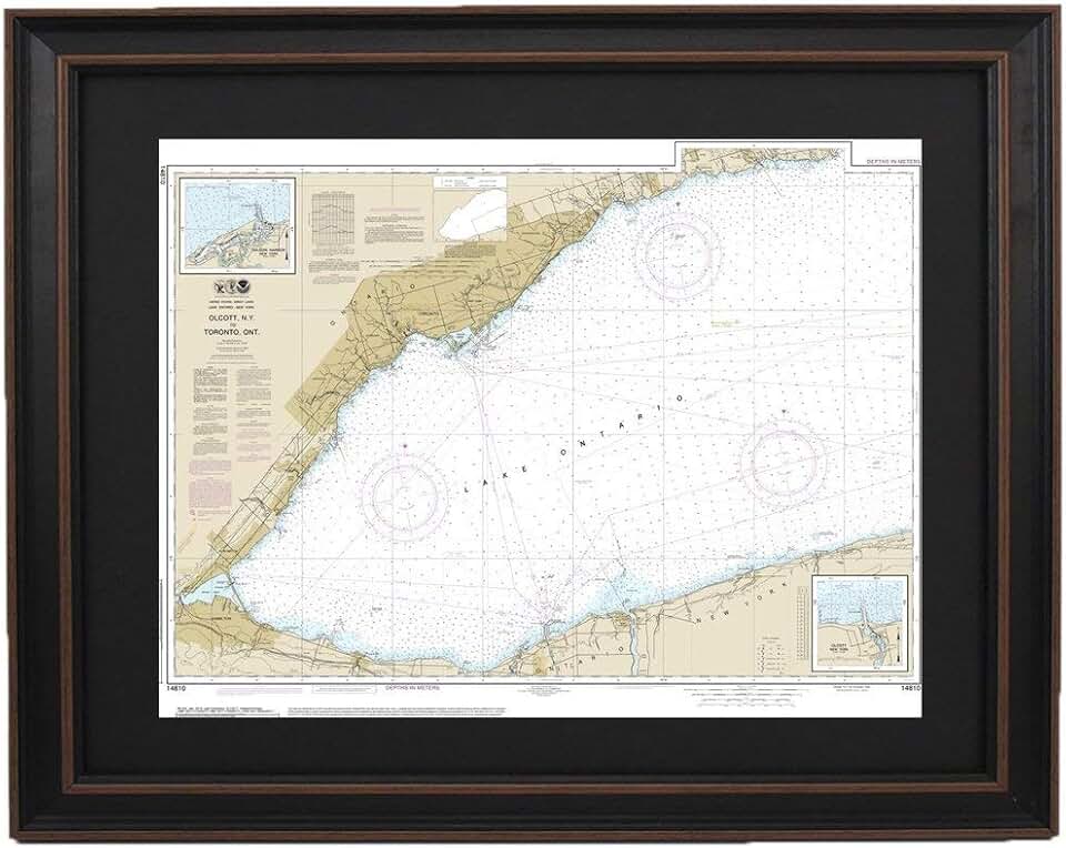
The Olcott Harbor Nautical Map, specifically the Framed Nautical Map 14810 covering Olcott Harbor to Toronto, is more than just a piece of wall art; it’s a meticulously crafted tribute to maritime heritage and geographical beauty. This handmade map, produced in the USA, offers a unique blend of historical significance and aesthetic appeal, making it a compelling choice for decor enthusiasts and boating aficionados alike.
Quick Summary: Olcott Harbor Nautical Map
- Rating: Not yet rated (0.0 stars from 0 reviews)
- Price: $324.99 USD
- Key Pros:
- Unique and visually striking decor piece.
- High-quality, handmade craftsmanship.
- Significant historical and geographical value.
- Supports US-based artisans and production.
- Perfect for specific themed rooms or enthusiasts.
- Key Cons:
- Premium price point.
- Niche appeal for a specific audience.
- Lack of customer reviews to gauge user satisfaction.
Table of Contents
Olcott Harbor Nautical Map Overview
The Olcott Harbor Nautical Map is a striking piece that captures the intricate details of a significant stretch of Lake Ontario. This particular map, identified as chart 14810, meticulously illustrates the waters and shorelines from Olcott Harbor, New York, extending across to Toronto, Canada, and includes detailed insets for Olcott and Wilson Harbors. It transforms complex navigational data into an aesthetically pleasing and informative display.
Nautical charts are traditionally used by mariners for safe navigation, depicting water depths, coastlines, navigational aids, and potential hazards. However, when framed and presented as wall art, these charts transcend their utilitarian purpose. They become powerful visual narratives, telling stories of voyages, local history, and the natural grandeur of large bodies of water like Lake Ontario.
This specific product is described as "Poster Size," suggesting a substantial dimension that allows for appreciating the fine details of the chart. The fact that it is "Handmade in USA" adds a significant layer of appeal, implying a commitment to quality craftsmanship and attention to detail that mass-produced items often lack. This manual approach ensures that each piece receives individual care during its creation, from printing to framing.
The geographic area covered is particularly interesting for those with ties to the Great Lakes region or a general appreciation for maritime history. Olcott Harbor, located on the southern shore of Lake Ontario, has a rich history as a port and recreational area. Wilson Harbor, nearby, also plays a significant role in local boating. Extending the map to Toronto provides a broader context, connecting these smaller harbors to a major international city across the lake.
For collectors and interior designers, such a map serves multiple functions. It can act as a focal point in a room, a conversation starter, or a subtle nod to personal interests in boating, geography, or local heritage. Its intricate lines, depth soundings, and place names offer endless visual exploration, inviting viewers to trace routes or imagine journeys across the water.
The absence of customer reviews and a rating, as indicated by the product listing, means that prospective buyers must rely on the product description and the inherent appeal of nautical maps. This lack of feedback is common for highly specialized or newly listed products, but it does mean buyers should consider the product’s intrinsic value and aesthetic rather than widespread user validation.
Ultimately, the Olcott Harbor Nautical Map is positioned as a premium decorative item. Its price reflects not just the material cost but also the specialized nature of the product, the detailed cartography, and the value placed on handmade, American-made goods. It’s an investment in a piece of art that carries both personal and historical weight.
Olcott Harbor Nautical Map Key Features & Specs
The Olcott Harbor Nautical Map (Chart 14810) boasts several distinctive features and specifications that set it apart as a unique decorative item. Understanding these details is crucial for appreciating its value and determining if it aligns with your aesthetic and interests. The combination of its specific geographical coverage, handmade nature, and framed presentation makes it a standout.
One of the primary features is its detailed geographical scope. The map covers the critical area from Olcott Harbor to Toronto, encompassing a significant portion of Lake Ontario. This includes the highly detailed insets for Olcott and Wilson Harbors, which are important local boating and fishing hubs. The specificity of this chart makes it particularly resonant for individuals with personal connections to these locations or a deep interest in Great Lakes navigation.
The designation "Poster Size" implies generous dimensions, though exact measurements are not provided in the listing. Typically, poster-sized maps are large enough to command attention on a wall, allowing the intricate details of the nautical chart to be easily visible and appreciated. This larger format enhances the visual impact and allows for a comprehensive display of the waterways, depths, and land features.
A key selling point is its "Handmade in USA" status. This signifies that the product is not mass-produced in an overseas factory but rather crafted with individual care and attention to detail by American artisans. This often translates to higher quality control, better material selection, and a more robust finished product. It also supports local economies and craftsmanship.
The map is described as "Framed," which means it comes ready to hang. The type of frame, its material, and color are not specified, but a professionally framed piece adds to its longevity and presentation. A good frame protects the map from dust, moisture, and UV damage, ensuring its beauty endures for years. The frame also contributes significantly to its finished aesthetic, ready to integrate into various decor styles.
Nautical maps are rich in information. This particular chart would display various data points essential for maritime navigation, including depth contours (isobaths), spot soundings (individual depth measurements), lighthouses, buoys, channels, and shorelines. It also indicates land features adjacent to the water, offering a comprehensive view of the coastal environment. For decorative purposes, these details provide visual texture and intellectual intrigue.
The map’s origin as a navigational chart (likely derived from NOAA or Canadian Hydrographic Service data) ensures its authenticity and historical accuracy. While intended for decor, its foundation in precise cartography adds a layer of educational and historical value. It represents a snapshot of the waterways as charted for mariners, preserving a piece of hydrographic history.
The materials used for printing are likely high-quality paper and inks to ensure clarity and longevity. For a premium, handmade item, one would expect fade-resistant inks and durable paper stock that can withstand the test of time without yellowing or deteriorating. The combination of these elements ensures that the Olcott Harbor Nautical Map is not just a temporary decoration but a lasting piece of art.
Pros & Cons
Evaluating any product requires a balanced look at its advantages and disadvantages. The Olcott Harbor Nautical Map, while a niche product, offers several compelling benefits alongside some considerations that potential buyers should weigh before purchasing. Its unique nature means its pros are often very strong for its target audience, while its cons might deter others.
Pros
- Unique and Visually Striking Decor: This map stands out from conventional wall art. Its intricate lines, subtle color palette, and detailed geographical information provide a sophisticated and intellectually engaging visual experience. It serves as a distinctive focal point in any room, sparking curiosity and conversation among guests.
- High-Quality, Handmade Craftsmanship: The "Handmade in USA" label is a significant advantage. It suggests a product created with meticulous attention to detail, superior material selection, and a level of care often absent in mass-produced items. This commitment to craftsmanship enhances the map’s durability and aesthetic appeal, making it a premium item.
- Significant Historical and Geographical Value: Nautical charts are historical documents that record the changing understanding of waterways. This specific map for Olcott Harbor and Lake Ontario carries intrinsic value for those interested in maritime history, regional geography, or the evolution of cartography. It’s not just decor; it’s a piece of documented history.
- Supports US-Based Artisans and Production: Purchasing this map contributes to the support of American craftsmanship and local businesses. This aspect is increasingly important for consumers who prioritize ethical sourcing and wish to invest in products that bolster domestic industries. It adds a layer of social value to the purchase.
- Perfect for Specific Themed Rooms or Enthusiasts: For anyone with a nautical, coastal, rustic, or even industrial theme, this map fits seamlessly. It’s an ideal choice for boat owners, sailors, residents of the Great Lakes region, or anyone with a passion for geography, travel, or the serene beauty of water. It caters to a specific, appreciative audience.
- Educational and Inspirational: Beyond its decorative function, the map can be an educational tool, helping to understand local geography and maritime features. It can also inspire dreams of travel, exploration, or simply provide a calming visual reminder of the vastness and beauty of Lake Ontario.
Cons
- Premium Price Point: At $324.99, this map is a significant investment for wall decor. While justified by its handmade quality and niche appeal, it places it outside the budget of many casual decorators. Buyers must truly value its unique attributes to warrant the cost.
- Niche Appeal for a Specific Audience: The subject matter — a specific nautical chart of Olcott Harbor to Toronto — will not appeal to everyone. Its aesthetic and informational value are best appreciated by those with a direct connection to the area or a strong interest in maritime themes. It’s not a universally appealing piece of art.
- Lack of Customer Reviews to Gauge User Satisfaction: With no ratings or reviews, prospective buyers lack direct feedback from previous customers. This means there’s less social proof regarding the product’s actual quality, the accuracy of its description, or overall satisfaction. Buyers must rely solely on the product description and their own judgment.
- Specific Aesthetic Might Not Fit All Decor: While versatile in some themed settings, the distinct look of a nautical chart might clash with very modern, minimalist, or highly colorful interior design styles. Its subdued colors and technical nature require a specific environment to truly shine.
- Limited Information on Frame Details: The listing mentions "Framed" but provides no specifics about the frame material, color, or style. This lack of detail can be a drawback for buyers who are particular about matching frames to their existing decor. It introduces an element of uncertainty regarding the final appearance.
Who Should Buy the Olcott Harbor Nautical Map?
The Olcott Harbor Nautical Map is not a generic piece of home decor; it’s a specialized item designed to appeal to a particular demographic. Its unique blend of artistic, historical, and geographical elements makes it perfect for certain individuals and settings. Understanding who stands to gain the most from this impressive framed map can help potential buyers make an informed decision.
Firstly, boating enthusiasts, sailors, and fishermen with a connection to Lake Ontario, especially the Olcott and Wilson Harbors, are prime candidates. This map offers a visual representation of their beloved waterways, perhaps even displaying routes they’ve sailed or fishing spots they frequent. It serves as a constant reminder of their passion and adventures on the water.
Secondly, residents and former residents of Olcott, Wilson, or the greater Lake Ontario region will find this map particularly meaningful. It acts as a beautiful homage to their local area, evoking a sense of place and nostalgia. It can be a wonderful way to celebrate their hometown or favorite vacation spot, bringing a piece of that geography into their living space.
History buffs and cartography collectors are another significant audience. Nautical maps are historical artifacts, reflecting the evolution of surveying and charting. This specific chart, detailing a particular moment in the mapping of Lake Ontario, offers a tangible link to maritime history. Its handmade nature further appeals to those who value authentic and carefully produced items.
Interior designers or individuals looking for unique and sophisticated wall art will appreciate the Olcott Harbor Nautical Map. Its subtle colors, intricate details, and historical context provide a focal point that is both elegant and thought-provoking. It works exceptionally well in spaces designed with a coastal, rustic, traditional, or even industrial aesthetic, adding character and depth.
The map also makes an exceptional and thoughtful gift for someone who fits any of the above descriptions. Imagine gifting this to a retired sailor, a new homeowner in Olcott, or a friend who loves the Great Lakes. It’s a personal and memorable present that shows a deep understanding of their interests and passions, far more unique than generic decor.
Furthermore, individuals who prioritize and appreciate handmade, American-made products will find this map appealing. The "Handmade in USA" aspect speaks to a commitment to quality, supporting local artisans, and often ensures a higher standard of craftsmanship compared to mass-produced alternatives. This aligns with a conscious consumerism philosophy.
Finally, anyone seeking a piece that combines aesthetic appeal with educational value could consider this map. It’s a beautiful item that also provides insight into geography and navigation. It can be a conversation starter, inviting discussions about travel, local history, or the natural environment of Lake Ontario. This dual function elevates it beyond mere decoration.
FAQ about Olcott Harbor Nautical Map
Prospective buyers often have specific questions about unique items like the Olcott Harbor Nautical Map. Here are answers to some common inquiries that can help clarify its features, purpose, and value.
Q1: What exactly is a nautical map, and how is it different from a regular map?
A nautical map, also known as a nautical chart, is a graphic representation of a sea or coastal area and adjacent coastal regions. Unlike a regular road map, it focuses on features relevant to marine navigation, such as water depths, shorelines, navigational aids (buoys, lighthouses), submerged dangers, and magnetic variations. This specific map is derived from official hydrographic data, making it a precise depiction of the waterways.
Q2: What specific areas does this Olcott Harbor Nautical Map cover?
This particular map, identified as Chart 14810, meticulously covers the waters and shorelines from Olcott Harbor, New York, extending across Lake Ontario to Toronto, Canada. It also includes highly detailed insets for both Olcott and Wilson Harbors. This comprehensive coverage makes it particularly relevant for anyone with an interest in this specific stretch of the Great Lakes.
Q3: Is the frame included with the purchase, and what can I expect regarding its quality?
Yes, the product description explicitly states "Framed Nautical Map," indicating that it comes pre-framed and ready to hang. While specific details about the frame material, color, or style are not provided, the "Handmade in USA" designation often implies a commitment to overall quality, suggesting a sturdy and well-finished frame that complements the map. You can often infer a certain standard of presentation from such craftsmanship.
Q4: What does "Handmade in USA" mean for this specific map?
"Handmade in USA" means that the entire process, from printing the map to its final framing, is carried out by skilled artisans within the United States. This typically ensures a high level of quality control, attention to detail, and the use of premium materials. It also supports American craftsmanship and local businesses, differentiating it from mass-produced imports.
Q5: How accurate are these decorative nautical maps for actual navigation?
While this framed map is derived from accurate nautical charts, it is primarily intended for decorative purposes and should not be used as the sole source for active navigation. Official charts, like those from NOAA (National Oceanic and Atmospheric Administration) or the Canadian Hydrographic Service, are regularly updated and should be consulted for real-time marine travel. This decorative version serves as a beautiful representation rather than a primary navigational tool.
Q6: What kind of interior design styles does this map complement best?
The Olcott Harbor Nautical Map is incredibly versatile and complements various interior design styles. It’s particularly well-suited for coastal, nautical, rustic, traditional, and even industrial-themed rooms. Its classic aesthetic and subdued color palette allow it to integrate seamlessly, adding a touch of sophistication, history, and natural beauty to your space. It can also be a striking contrast in a more modern setting.
Q7: Is this map a good gift idea, and for whom?
Absolutely, this map makes an excellent and highly thoughtful gift. It’s ideal for anyone who loves boating, has a connection to Lake Ontario or the specific harbors (Olcott, Wilson), is a history enthusiast, or appreciates unique, handmade home decor. It’s a personal and memorable present that stands out from generic gifts, especially for those with a passion for geography or maritime themes.
Q8: What is the historical significance of Olcott Harbor?
Olcott Harbor, located on Lake Ontario, has a rich history as a port and recreational area in New York. It has served as a hub for shipping, fishing, and passenger ferries, connecting communities along the lake. Today, it’s known for its picturesque harbor, lighthouse, and recreational activities, making it a beloved spot for locals and tourists. The map captures a piece of this enduring maritime legacy. You can learn more about the region’s history on resources like Wikipedia’s page on Olcott, New York.
Final Verdict
The Olcott Harbor Nautical Map is an undeniably impressive and distinctive piece of wall decor, offering far more than just visual appeal. It serves as a testament to the artistry of cartography and the enduring allure of maritime history. For those with a deep appreciation for Lake Ontario, boating, or unique handmade items, this framed map stands out as an exceptional choice.
While the premium price point and the lack of customer reviews might give some pause, the inherent value of a handmade, USA-produced item with such specific geographical and historical significance cannot be overstated. It’s an investment in a piece that tells a story, sparks conversation, and adds a profound layer of character to any space. The detailed rendering of Olcott Harbor to Toronto is a visual delight for enthusiasts.
Ultimately, if you are seeking a generic piece of art, this may not be for you. However, if you are a boating enthusiast, a resident of the Great Lakes region, a history buff, or someone who values artisanal craftsmanship and unique geographical representations, the Olcott Harbor Nautical Map is an outstanding and worthwhile addition to your home or office. It’s more than just a map; it’s a window into a world of waterways and history, beautifully presented.