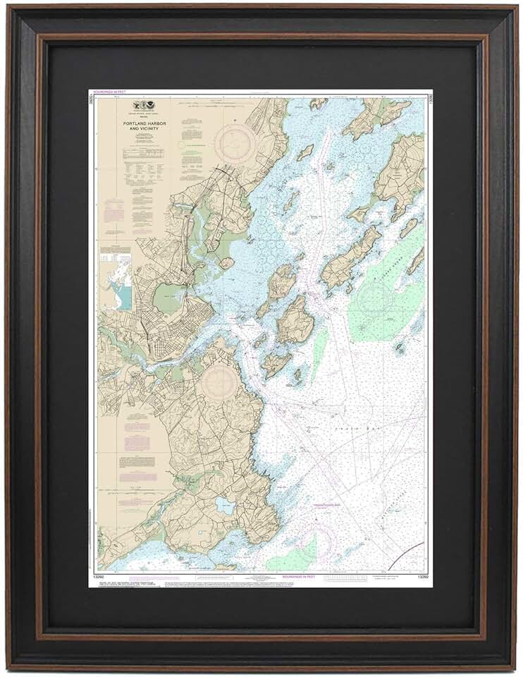
The Framed Nautical Map Portland offers a unique blend of historical cartography and exquisite home decor, making it a compelling addition to any space. This particular piece, identified as Nautical Map 13292, meticulously depicts the intricate waterways and coastal features of Portland Harbor, presented in a ready-to-hang, poster-sized format. Crafted with an emphasis on quality and authenticity, it serves as more than just a decorative item; it’s a testament to maritime heritage.
Quick Summary: Framed Nautical Map Portland
An exceptional, handmade framed map showcasing Portland Harbor.
- Rating: Not yet rated (0.0/5.0)
- Price: $324.99
- Key Pros:
- Authentic and detailed nautical decor
- High-quality handmade craftsmanship from USA
- Unique focus on Portland Harbor, appealing to enthusiasts
- Key Cons:
- Premium price point may deter some buyers
- Specific geographical focus limits universal appeal
Table of Contents
Framed Nautical Map Portland Overview
The Framed Nautical Map Portland is a meticulously crafted piece of art that appeals to maritime enthusiasts, history buffs, and those with an appreciation for unique coastal decor. This product is not merely a poster but a carefully produced, framed representation of a specific nautical chart, ensuring both aesthetic appeal and geographical accuracy. Its handmade nature, proudly originating from the USA, underscores a commitment to quality and attention to detail that mass-produced items often lack.
Nautical charts have a rich history, serving as essential tools for navigation for centuries. They represent the culmination of extensive hydrographic surveys, detailing depths, shorelines, navigational aids, and potential hazards. The chart number 13292, which this framed map is based upon, specifically covers the vital waters of Portland Harbor, a historically significant port on the coast of Maine.
This framed map transcends its utilitarian origins to become a striking decorative element. It allows individuals to bring a piece of maritime history and geographical specificity into their homes, offices, or commercial spaces. The poster size ensures that the intricate details of the harbor, from channel markers to coastal contours, are clearly visible and can be appreciated from a distance.
The artistic value of such a piece lies in its ability to evoke a sense of place and adventure. For residents of Portland, or those with fond memories of the area, it serves as a powerful reminder of home or past experiences. For others, it might spark curiosity about maritime exploration and the beauty of coastal landscapes. This makes the Framed Nautical Map Portland a conversation starter, inviting viewers to delve into its depths.
The decision to offer this map framed indicates a focus on convenience and presentation. Buyers receive a ready-to-hang product, eliminating the need for separate framing services and ensuring that the map is protected and displayed professionally from the moment it arrives. This all-in-one solution adds significant value, especially for those who prioritize ease of installation and a polished final look.
In essence, this product bridges the gap between historical documentation and modern home aesthetics. It celebrates the intricate science of cartography while delivering a visually appealing and emotionally resonant piece of decor. The handmade aspect further ensures that each map possesses a unique character, distinguishing it from generic prints and lending it an artisanal charm that complements various interior design themes, from traditional to contemporary coastal.
Understanding the specific details of Nautical Chart 13292 is crucial for appreciating the product’s depth. These charts are typically produced by governmental agencies, such as the National Oceanic and Atmospheric Administration (NOAA) in the United States. They provide critical information for mariners, including depths, aids to navigation, dangers, and land features. The accuracy and detail of these charts are paramount for safe passage, and their aesthetic appeal is a bonus. You can learn more about NOAA charts at nauticalcharts.noaa.gov.
This particular map not only showcases the geography but also subtly narrates the story of a bustling port. It highlights the intricate dance between land and sea, the infrastructure supporting maritime trade, and the natural beauty of the Maine coast. For anyone seeking to infuse their living space with character and a touch of nautical elegance, the Framed Nautical Map Portland presents an outstanding option.
Framed Nautical Map Portland Key Features & Specs
The distinct appeal of the Framed Nautical Map Portland lies in its specific features and specifications, which combine to create a premium decorative item. Understanding these details helps in appreciating the value and craftsmanship inherent in this product. From its overall dimensions to the materials used, each element contributes to its quality and aesthetic impact.
One of the primary features is its classification as a “Poster Size” map. While exact dimensions are not provided in the initial listing, this typically implies a substantial size, large enough to command attention on a wall and allow for clear viewing of the intricate details. A generous size enhances its visual presence and makes the map’s cartographic elements more legible, which is crucial for a nautical chart.
The phrase “Handmade in USA” is a significant selling point, emphasizing the artisanal quality and attention to detail. This indicates that the framing, mounting, and potentially even the printing process are not automated but involve human touch and expertise. Handmade products often boast superior finish and durability compared to their mass-produced counterparts, reflecting a commitment to traditional craftsmanship.
As a “Framed Nautical Map 13292,” the product arrives ready for display. The framing itself is a key component, protecting the map from environmental damage such as dust, moisture, and UV light, which can cause fading over time. A quality frame also enhances the map’s aesthetic, providing a finished, professional look that complements the detailed chart within.
While specific frame materials (e.g., wood type, finish) and glazing (e.g., acrylic, glass, UV-protective) are not detailed, a premium product at this price point suggests a robust and aesthetically pleasing frame. Typically, such frames would feature solid wood construction or high-quality composite materials, chosen to complement the nautical theme. The glazing would ideally be clear and offer some level of UV protection to preserve the map’s colors.
The map itself is based on Nautical Chart 13292, which focuses on Portland Harbor. This means the map contains accurate, official hydrographic data, including water depths, navigation channels, buoys, lights, lighthouses, and coastal landmarks. The precision of this information is paramount, even in a decorative context, as it lends authenticity and educational value to the piece.
The paper quality used for the map print is also critical. High-quality, archival-grade paper would ensure the map’s longevity and prevent yellowing or deterioration over time. The printing process would ideally use fade-resistant inks to maintain the vibrancy of the chart’s colors and legibility of its fine lines for many years to come. These details, though often unseen, contribute significantly to the overall durability and lasting beauty of the framed map.
Another implicit feature is the inclusion of proper mounting hardware. A well-framed piece of art should come with suitable hooks or wires, making it easy for the buyer to hang it securely upon arrival. This attention to user experience further enhances the product’s value and convenience. The combination of historical accuracy, quality materials, and expert craftsmanship makes the Framed Nautical Map Portland a standout piece for any decor.
Considering the price point, one can anticipate that the materials used for both the map printing and the framing are of a superior standard. This includes not just the physical components but also the meticulous process of assembling the map within its frame, ensuring it is perfectly aligned, free of bubbles, and securely sealed. This commitment to quality justifies its position as a premium home decor item, distinct from mass-produced prints. For additional information on the geography of Portland Harbor, Wikipedia offers a good resource: Portland Harbor Wikipedia.
Pros & Cons
Evaluating any product involves weighing its advantages against its potential drawbacks. The Framed Nautical Map Portland, while offering significant appeal, also comes with certain considerations. A balanced perspective helps potential buyers make an informed decision about whether this unique piece of decor is the right fit for their needs and preferences.
Pros
- Authentic and Detailed Nautical Decor: This map is not a generic artistic interpretation but a reproduction of an actual nautical chart (13292). This authenticity provides a layer of historical and geographical accuracy that is highly valued by maritime enthusiasts. The details, from depth soundings to navigational aids, are true to the original chart, offering both beauty and educational insight.
- High-Quality Handmade Craftsmanship from USA: The