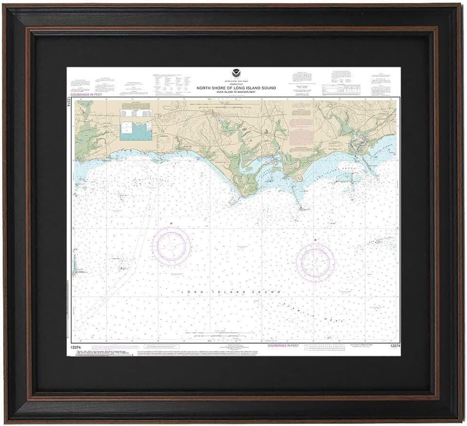
The Framed Nautical Map 12374 offers a unique blend of historical cartography and elegant home decor. This impressive piece showcases the North Shore of Long Island Sound, specifically detailing the area from Duck Island to Madison Reef. It’s not merely a map; it is a meticulously crafted work of art designed to captivate and educate.
Quick Summary: Framed Nautical Map 12374
Rating: Not yet rated (0.0/5.0)
Price: $324.99 USD
Key Pros:
- Exquisite Detail: Presents a highly accurate and visually appealing depiction of the Long Island Sound coastline, appealing to both navigators and art enthusiasts.
- Handmade in USA: Ensures a high level of craftsmanship and attention to detail, supporting local artisans and guaranteeing quality.
- Unique Decorative Piece: Serves as a sophisticated focal point in any room, adding character and a touch of maritime history to your home or office decor.
Key Cons:
- Premium Price Point: Positioned at a higher price, which might be a consideration for budget-conscious buyers despite its artistic and quality merits.
- Niche Appeal: While beautiful, its specific geographical focus might limit its appeal to those without a personal connection to the Long Island Sound area.
Table of Contents
Framed Nautical Map 12374 Overview
The Framed Nautical Map 12374 stands out as more than just a navigational tool; it is a meticulously crafted piece of art that brings the beauty and complexity of coastal navigation into your living space. This poster-sized map specifically details the North Shore of Long Island Sound, covering the intricate waterways and coastlines from Duck Island to Madison Reef. It captures a specific and historically significant stretch of water, making it deeply resonant for those familiar with the area.
Nautical charts have a rich history, serving as essential guides for mariners for centuries. They combine precise measurements of depth, shorelines, navigational aids, and hazards, all presented in a standardized, artistic format. This particular map transforms such a functional document into a decorative item, preserving its inherent detail while elevating its aesthetic appeal for display in homes, offices, or maritime-themed establishments.
The decision to frame this chart elevates it from a utilitarian object to a piece of fine art. Framing protects the map from environmental damage, such as dust, moisture, and UV light, which can cause fading over time. It also provides a finished, professional look that integrates seamlessly into various interior design schemes, from traditional to contemporary.
As a decorative piece, the Framed Nautical Map 12374 offers a compelling focal point. Its intricate lines, varying depths indicated by color gradients, and textual annotations invite closer inspection and conversation. It can evoke memories of coastal adventures, inspire future voyages, or simply serve as an appreciation for the art of cartography and the beauty of the Long Island Sound region.
The area depicted, from Duck Island to Madison Reef, is well-known for its picturesque coastlines, vibrant boating communities, and significant ecological features. This geographical specificity makes the map particularly meaningful for residents, boaters, and visitors who have a personal connection to this part of Connecticut and New York. It acts as a tangible link to cherished experiences and local heritage.
The absence of customer reviews or a rating at the time of this review suggests that this product might be a newer offering or a specialized item with a targeted audience. However, the description of it being ‘Handmade in USA’ implies a commitment to quality and craftsmanship, which is often a hallmark of premium decorative items. The handmade aspect usually means greater attention to detail and unique character compared to mass-produced alternatives.
Considering its poster size, the map commands attention and allows for the appreciation of its fine details without straining the eyes. This scale is ideal for wall mounting, ensuring that the visual impact of the chart is maximized. It’s designed to be observed and studied, not just glanced at, offering a continuous source of visual interest and geographical insight.
Ultimately, the Framed Nautical Map 12374 is positioned as a high-quality, decorative item for those who value unique art, maritime history, and a connection to the Long Island Sound. Its combination of utility, artistry, and localized appeal makes it a distinct offering in the realm of home and office decor. It’s a statement piece that speaks to a love for the sea and the precision of historical mapping.
Framed Nautical Map 12374 Key Features & Specs
The Framed Nautical Map 12374 boasts several key features and specifications that contribute to its appeal as both a decorative item and a piece of cartographic history. Understanding these details helps in appreciating the value and craftsmanship inherent in this unique product. Its primary function is aesthetic, but the underlying data holds genuine geographical significance.
One of the most significant features is its depiction of the North Shore of Long Island Sound, specifically from Duck Island to Madison Reef. This precise geographical focus is a core selling point, offering a highly detailed and accurate representation of a particular coastal area. For those with a personal or professional connection to this region, the map holds immense sentimental and practical value.
The product is described as a ‘Poster Size’ map. While exact dimensions are not provided, this implies a substantial visual presence, making it suitable for prominent wall display. A larger format allows for the intricate details of the nautical chart – depth soundings, navigational buoys, shorelines, and place names – to be clearly visible and appreciated from a distance, enhancing its decorative impact.
A crucial aspect of its quality is that it is ‘Handmade in USA’. This designation typically signifies a commitment to high standards of craftsmanship and materials. Handmade items often possess a unique character and a level of attention to detail that mass-produced goods might lack. It also supports local artisans and ensures ethical production practices.
The term ‘Framed’ is central to the product’s identity. While the specific frame material (wood, metal), color, or style is not detailed, the inclusion of a frame means the map arrives ready to hang. A quality frame protects the map from environmental factors like humidity and dust, and prevents creasing or damage. It also elevates the map into a finished art piece, ready for immediate display.
Nautical charts themselves are marvels of data visualization. They use various symbols, colors, and contour lines to convey complex information about water depths, land elevations, and potential hazards. The Framed Nautical Map 12374 preserves this rich informational layer, inviting viewers to explore the geographical nuances of the Long Island Sound.
The chart number, 12374, is also a specific identifier. Nautical charts are systematically numbered by official agencies, such as NOAA (National Oceanic and Atmospheric Administration) in the United States, to denote specific regions and scales. This number confirms its authenticity as a derived or reproduced official chart, adding to its credibility and historical accuracy. You can often find more information about the original chart by looking up its number on official charting websites.
The purpose of such a product is dual: both aesthetic and informational. While most buyers will purchase it for its decorative qualities, it still serves as an accurate representation of the specified waters. This blend of form and function makes it a compelling item for anyone interested in maritime themes, coastal geography, or unique wall art. The enduring appeal of nautical charts lies in their blend of scientific precision and artistic presentation.
In summary, the Framed Nautical Map 12374 offers a large-format, handmade, and framed representation of a significant portion of the Long Island Sound. Its authenticity as a numbered chart, combined with the quality of its presentation, makes it an impressive and educational decorative piece. This product is designed to bring a touch of maritime elegance and geographical appreciation into any setting.
Pros & Cons
Evaluating the Framed Nautical Map 12374 involves weighing its significant advantages against potential drawbacks. This balance helps prospective buyers determine if the product aligns with their expectations and needs. Understanding both sides ensures a well-informed purchasing decision.
Pros of the Framed Nautical Map 12374:
- Exquisite Detail and Accuracy: The map provides a highly detailed and cartographically accurate representation of the North Shore of Long Island Sound. This precision makes it fascinating for anyone interested in geography, navigation, or the specific region. The intricate lines, depth markers, and land features are rendered with clarity, offering endless visual exploration.
- Handmade in USA Quality: The ‘Handmade in USA’ label is a strong indicator of superior craftsmanship. This suggests that the map and its framing are produced with meticulous attention to detail and high-quality materials. Such products often offer better durability and a more refined finish than mass-produced alternatives, contributing to its overall artistic value.
- Unique and Sophisticated Decor: This isn’t just a generic piece of wall art; it’s a conversation starter. The nautical theme, combined with the historical and geographical context, makes it a sophisticated and distinctive addition to any room. It can effortlessly elevate the aesthetic of a study, living room, office, or coastal-themed space, making it truly stand out.
- Ready-to-Hang Convenience: Being framed, the map arrives ready for immediate display. This eliminates the extra cost, time, and effort of finding a suitable frame and having it professionally mounted. The integrated frame ensures the map is protected and presents a polished, complete look right out of the box, saving you hassle.
- Educational and Inspirational Value: Beyond its decorative appeal, the map serves an educational purpose. It allows viewers to learn about the topography and hydrography of Long Island Sound. For boaters, it can inspire future trips; for others, it can spark an interest in cartography, maritime history, or local geography, offering more than just visual pleasure.
- Personal Connection and Nostalgia: For individuals who have lived near, visited, or sailed the Long Island Sound, this map offers a powerful sense of connection and nostalgia. It can be a cherished reminder of personal experiences, family vacations, or a beloved coastal heritage. This emotional resonance adds significant value beyond mere aesthetics.
Cons of the Framed Nautical Map 12374:
- Premium Price Point: At $324.99, the Framed Nautical Map 12374 is an investment. This price reflects the handmade quality, framing, and specialized nature of the product. However, it might be a significant consideration for buyers with a limited budget for home decor, potentially making it inaccessible to some.
- Niche Appeal and Specificity: While its detailed focus on Long Island Sound is a pro for some, it’s a con for others. The map’s specific geographical area may not resonate with individuals who lack a connection to this particular region. Its niche appeal means it might not be a universal choice for home decor, limiting its broader market.
- Lack of Customer Reviews: The absence of customer ratings and reviews on Amazon means prospective buyers cannot benefit from the experiences and opinions of previous purchasers. This lack of social proof can make it challenging to gauge real-world satisfaction, durability, or accurate representation of the product, requiring buyers to rely solely on the product description.
- Potential for Limited Customization: While the map comes framed, there is no indication of frame style or color options. Buyers might be limited to a single frame design, which may not perfectly match every interior decor scheme. The inability to customize could be a drawback for those seeking a highly personalized look.
Who Should Buy the Framed Nautical Map 12374?
The Framed Nautical Map 12374 is a specialized and premium decorative item, making it ideal for a particular set of individuals and settings. Its unique characteristics mean it won’t appeal to everyone, but for the right buyer, it offers exceptional value and aesthetic pleasure. Let’s explore the various personas who would find this nautical map an impressive addition.
Coastal Homeowners and Residents:
Individuals who own homes along the North Shore of Long Island Sound, or anywhere in the broader Long Island and Connecticut coastal regions, are prime candidates. This map provides a direct connection to their local environment, celebrating the beauty and distinctiveness of their surroundings. It serves as a proud display of local pride and a tangible link to their community.
Boating Enthusiasts and Mariners:
Anyone with a passion for boating, sailing, or maritime activities will appreciate the intricate details of a genuine nautical chart. Sailors, powerboaters, and even kayakers who frequent the waters from Duck Island to Madison Reef will find this map fascinating. It can serve as a nostalgic reminder of past voyages or a planning tool for future adventures, hanging proudly in a study or boat house.
Interior Designers and Decorators:
For professionals or individuals looking to create a specific aesthetic, especially coastal, maritime, or traditional decor, this map is an excellent choice. Its sophisticated blend of historical charm and precise cartography adds a unique focal point to any room. It provides an authentic touch that elevates a themed interior beyond generic decorations, offering depth and character.
Collectors of Maps and Maritime Memorabilia:
Map collectors, cartography enthusiasts, or those who collect maritime artifacts will find the Framed Nautical Map 12374 to be a valuable addition. The fact that it’s a specific chart number (12374) and handmade adds to its collectible appeal. It represents a piece of geographical and artistic history, worthy of display in a dedicated collection.
Gift Seekers for Special Occasions:
This framed map makes a thoughtful and unique gift for milestones such as retirements, housewarmings in coastal areas, birthdays for boating enthusiasts, or anniversaries. It’s a personal and memorable present that reflects a deep understanding of the recipient’s interests or connection to a particular place. Its premium nature ensures it feels like a truly special offering.
Office and Commercial Spaces:
Businesses located near the Long Island Sound, such as marinas, yacht clubs, coastal real estate offices, or even local restaurants, could use this map as a distinctive piece of decor. It enhances the ambiance, provides a talking point for clients, and reinforces a connection to the local maritime heritage. It projects an image of professionalism and local appreciation.
Educators and History Buffs:
For those interested in historical mapping techniques, geography, or the specific history of the Long Island Sound, this map offers rich educational content. It can be used as a teaching aid or simply as a source of personal learning and appreciation for the evolution of cartography. The detailed nature of such charts offers a window into past navigational practices.
Anyone Seeking Unique, High-Quality Wall Art:
Even without a direct connection to Long Island Sound, individuals who appreciate unique, high-quality, and visually engaging wall art will find this map appealing. Its intricate design, historical context, and the implied story behind it make it a captivating alternative to more conventional prints or paintings. The handmade aspect further elevates its artistic merit.
In conclusion, the Framed Nautical Map 12374 is best suited for those who value authenticity, craftsmanship, and a deep connection to maritime culture or specific geographical locations. It’s an investment in a piece that offers both aesthetic beauty and intellectual engagement, making it far more than just a picture on a wall. It’s a testament to the enduring allure of the sea and the precision of cartography.
FAQ about Framed Nautical Map 12374
Here are some frequently asked questions about the Framed Nautical Map 12374, providing further insights into its features, care, and overall value. These answers aim to address common concerns and enhance understanding for potential buyers. Knowing these details can help you make a more informed decision and appreciate the product fully.
Q1: What specific area does the Framed Nautical Map 12374 cover?
A1: The map specifically details the North Shore of Long Island Sound, focusing on the stretch of coastline and waters from Duck Island to Madison Reef. This covers a significant and picturesque portion of the Connecticut shoreline and adjacent Long Island waters. It’s a precise geographical snapshot, offering rich local detail.
Q2: Is this an original historical map, or a reproduction?
A2: While the description doesn’t explicitly state ‘original,’ the product is listed as ‘Framed Nautical Map 12374.’ This implies it is a high-quality reproduction or print of an official nautical chart identified by the number 12374. Such reproductions maintain the historical accuracy and detail of the original chart while being suitable for decorative display. You can learn more about nautical charts and their production process.
Q3: What does ‘Handmade in USA’ imply for the product’s quality?
A3: ‘Handmade in USA’ suggests that the map print and its framing are assembled with individual care and attention to detail by skilled artisans within the United States. This typically translates to higher quality materials, better construction, and a more unique finish compared to mass-produced items. It ensures a premium product and often supports local craftsmanship and businesses.
Q4: What are the typical dimensions of a ‘Poster Size’ framed map?
A4: While exact dimensions are not provided for this specific product, ‘Poster Size’ generally refers to a substantial size, often ranging from approximately 24×36 inches (61×91 cm) to 30×40 inches (76×102 cm) or larger. This ensures the intricate details of the nautical chart are clearly visible and that the map makes a significant visual impact as wall decor.
Q5: How should I care for and clean my Framed Nautical Map 12374?
A5: To care for your framed map, avoid placing it in direct sunlight, which can cause fading over time. Keep it away from areas with high humidity or extreme temperature fluctuations to prevent damage to the print and frame. For cleaning, gently dust the frame and glass with a soft, dry cloth. If necessary, lightly dampen the cloth with a mild glass cleaner for the glass, ensuring no liquid seeps into the frame or onto the map itself. Regular gentle cleaning will help preserve its appearance for years.
Q6: Can I get this map with a different frame style or color?
A6: The product listing specifies it as ‘Framed Nautical Map 12374,’ implying it comes with a pre-selected frame. Without options listed, it’s generally assumed that customization of the frame style or color is not available directly from this listing. If you desire a different frame, you would likely need to purchase the map and then have it re-framed locally, which would incur additional costs. This product is sold as a complete, ready-to-hang piece.
Q7: What makes nautical charts so appealing as decorative items?
A7: Nautical charts are appealing as decor due to their unique blend of scientific precision, historical significance, and artistic design. Their intricate lines, symbols, and varying color gradients (representing depth) create a visually rich texture. They evoke a sense of adventure, nostalgia for the sea, and a connection to coastal living. Furthermore, they offer an intellectual engagement, inviting viewers to study the geography and navigational details. Many people appreciate the authenticity and craftsmanship involved, especially when learning about official charting agencies like NOAA’s charting mission.
Q8: Is this map suitable for actual navigation?
A8: While this framed map is a reproduction of an official nautical chart, it is primarily intended for decorative purposes. For actual navigation, especially for critical decision-making on the water, always rely on the most current, official, and up-to-date electronic or paper charts issued by relevant hydrographic authorities. Display maps may not reflect the latest changes in navigational aids, depths, or hazards. Always prioritize safety and use official, current resources for active navigation. This framed map is best enjoyed as a piece of art and a historical reference.
Final Verdict
The Framed Nautical Map 12374 emerges as an impressive and sophisticated piece of wall art, perfectly blending historical cartography with elegant home decor. Its detailed depiction of the North Shore of Long Island Sound, from Duck Island to Madison Reef, offers a unique and personal connection for those familiar with the region. This is more than just a picture; it’s a window into a specific coastal environment, rich with geographical and maritime significance.
The ‘Handmade in USA’ designation underscores a commitment to quality and craftsmanship, ensuring that both the print and its frame are produced with care and attention to detail. This results in a finished product that feels substantial and refined, ready to enhance any room. The poster size guarantees a significant visual impact, allowing the intricate details of the nautical chart to be fully appreciated.
While the premium price point of $324.99 places it in the investment category for home decor, it reflects the specialized nature, quality materials, and artisanal production. This is not a mass-produced item but a distinctive piece designed to be cherished. The lack of customer reviews currently means potential buyers must rely on the product description and their own appreciation for nautical art.
For individuals seeking a unique gift, coastal homeowners, boating enthusiasts, or anyone wanting to infuse their space with a touch of maritime history and sophistication, the Framed Nautical Map 12374 is an outstanding choice. It serves not only as a decorative element but also as a conversation starter and a source of geographical inspiration. Its educational value, combined with its aesthetic appeal, provides a multi-faceted experience.
Ultimately, this framed nautical map stands as a testament to the enduring allure of the sea and the precision of human cartography. It’s a statement piece that speaks volumes about an appreciation for quality, history, and the beauty of specific coastal landscapes. If you’re looking for an impressive and meaningful addition to your decor that offers both visual charm and intellectual depth, this map is undoubtedly worth considering.