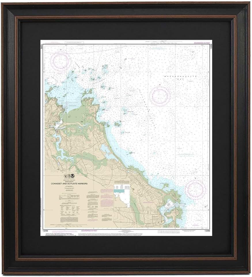
The **Framed Nautical Map** of Cohasset and Scituate Harbors represents more than just a decorative piece; it’s a meticulously crafted artwork that brings history, geography, and aesthetic appeal into your living space. This particular map, handmade in the USA, captures the intricate details of these iconic Massachusetts coastal areas, making it a focal point for any room with a nautical or coastal theme.
Quick Summary: Framed Nautical Map
- Rating: Not yet rated (0.0/5.0)
- Price: $324.99 USD
- Key Pros:
- Authentic, detailed nautical cartography
- Handmade in the USA, ensuring unique craftsmanship
- High-quality framing enhances aesthetic appeal
- Perfect for nautical-themed decor or coastal homes
- Poster size makes it a significant focal point
- Key Cons:
- Premium price point for a decorative map
- Specific geographic focus might limit universal appeal
Table of Contents
Framed Nautical Map Overview
The **Framed Nautical Map** of Cohasset and Scituate Harbors is a testament to classic cartography and artisanal craftsmanship. This large-format print is not merely a reproduction but a carefully prepared piece of art designed to evoke a sense of coastal charm and historical appreciation. It brings the intricate details of seafaring charts into a decorative context.
This particular map showcases the distinctive coastlines, waterways, and depths of two historically significant Massachusetts harbors. Cohasset and Scituate are renowned for their picturesque maritime heritage, and this map beautifully captures their unique geographical essence. It serves as an excellent conversation starter and a visual journey for anyone with a connection to these areas or a love for the sea.
Unlike mass-produced prints, this **Framed Nautical Map** is handmade in the USA, suggesting a commitment to quality and attention to detail. The process of creating such a piece often involves careful selection of materials, precise printing techniques, and expert framing to ensure longevity and aesthetic appeal. This handmade aspect contributes significantly to its perceived value and uniqueness.
The poster size of the map ensures it commands attention, making it suitable for larger walls in living rooms, studies, or offices. Its dimensions allow for easy readability of the detailed nautical information, from depth soundings to buoy placements. This scale is crucial for appreciating the complexity and beauty of traditional charting.
The choice of a framed presentation means the artwork arrives ready to hang, eliminating the need for separate framing. The frame itself is an integral part of the overall aesthetic, often chosen to complement the map’s style and enhance its visual impact. This convenience adds to the product’s appeal for interior decorators and homeowners alike, offering a complete decor solution.
For those passionate about marine navigation, local history, or coastal aesthetics, this **Framed Nautical Map** offers a unique blend of all three. It provides an opportunity to connect with the past and appreciate the art of charting, all while enhancing the ambiance of a chosen space. Its specific focus on Cohasset and Scituate makes it particularly resonant for residents, visitors, or those with ancestral ties to these charming New England towns.
The investment in such a piece reflects an appreciation for quality, craftsmanship, and a desire to incorporate meaningful art into one’s home. While it comes at a premium price, the handmade nature and specific subject matter differentiate it from generic wall art. It’s an item that tells a story and holds a certain gravitas, embodying the spirit of maritime exploration and local pride.
Considering the absence of customer reviews, evaluating this product relies heavily on its description and the inherent qualities of such specialized items. The value proposition lies in its unique artistry, the specificity of its subject, and the promise of American craftsmanship. It appeals to a discerning buyer who values authenticity and a connection to nautical heritage.
Framed Nautical Map Key Features & Specs
The **Framed Nautical Map** of Cohasset and Scituate Harbors boasts several distinctive features and specifications that contribute to its overall quality and appeal. Understanding these details helps in appreciating the value and craftsmanship inherent in this unique piece of art. Each element is carefully considered to deliver an authentic and visually striking product.
Detailed Cartography and Geographic Focus
At its core, this product is an authentic nautical chart, meticulously depicting the waters surrounding Cohasset and Scituate Harbors. It includes essential navigational information such as water depths, buoy locations, channels, and coastal landmarks. This level of detail is crucial for both aesthetic authenticity and historical accuracy, making it more than just a generic picture.
The geographical specificity to Cohasset and Scituate, Massachusetts, means the map holds particular significance for individuals with ties to these coastal communities. It offers a nostalgic or aspirational connection to a specific locale, differentiating it from broader, less personal nautical art. The chart data is likely sourced from reputable hydrographic offices, ensuring accuracy.
Handmade in USA Craftsmanship
The designation of being “Handmade in USA” signifies a commitment to quality and artisanal production. This typically implies that the map is not mass-produced in an automated factory but rather created with individual attention and skill. Such craftsmanship often results in a higher standard of finish and a unique character that machine-made items lack.
The handmade process likely extends to the printing, mounting, and framing of the map. This attention to detail can ensure crisp print quality, precise alignment within the frame, and a durable construction. Supporting handmade American products also appeals to consumers who prioritize local economies and traditional artisan skills.
Poster Size Dimensions
While exact dimensions are not provided in the product description,