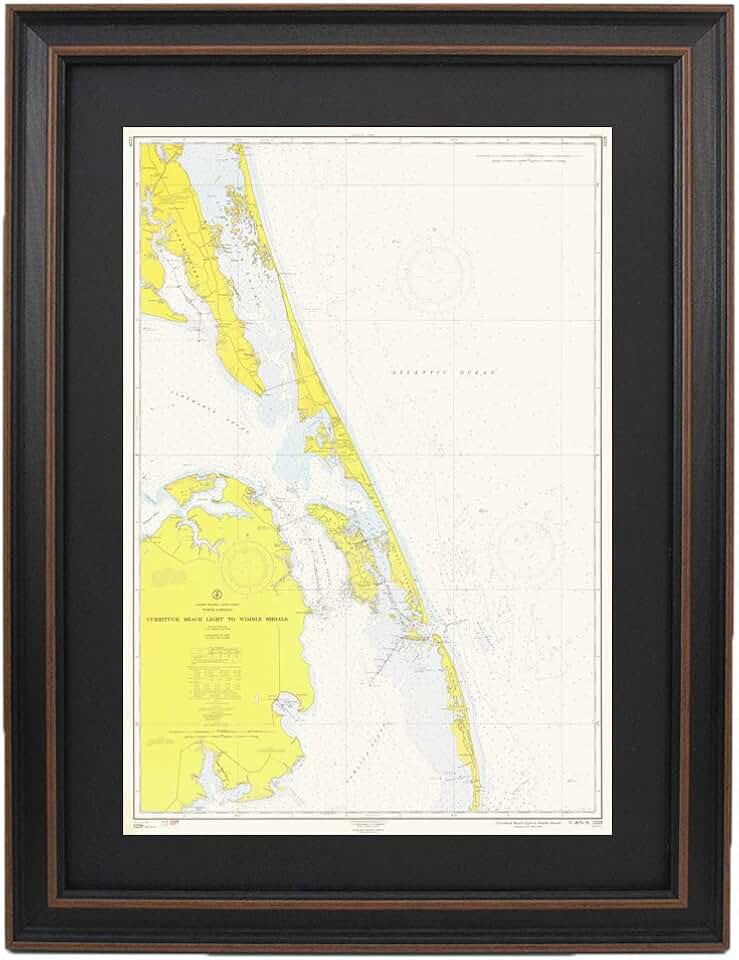
The allure of the sea, its history, and exploration, is beautifully captured in products like the Vintage Nautical Maps: Outer Banks; Currituck Beach Light to Wimble Shoals. This 1961 replica, handmade in the USA, offers a unique blend of historical charm and artistic elegance, making it a standout piece for any home or office.
As a reviewer of home renovation and garden products, I’ve seen countless decor items, but few possess the unique character and storytelling potential of these meticulously crafted vintage maps. They serve not just as wall art but as a window into a bygone era of maritime navigation and coastal life.
Quick Summary
- Rating: Not yet rated
- Price: $169.99 USD
- Key Pros:
- Authentic 1961 replica offers historical charm and detail.
- High-quality, handmade craftsmanship from the USA.
- Unique and impressive coastal-themed decor.
- Key Cons:
- Niche appeal due to specific geographic focus.
- Premium price point may not suit all budgets.
Table of Contents
Vintage Nautical Maps Overview
The Vintage Nautical Maps of the Outer Banks, specifically featuring the stretch from Currituck Beach Light to Wimble Shoals, are far more than just decorative pieces; they are historical artifacts presented as art. This 1961 replica captures a precise moment in time, offering a glimpse into how mariners navigated these iconic coastal waters decades ago.
Each map is a meticulously crafted reproduction of an original nautical chart, preserving the intricate details, typography, and symbols that were crucial for navigation. The choice of a 1961 chart adds significant historical weight, reflecting the cartographic standards and coastal features of that era.
What truly sets these Vintage Nautical Maps apart is their framed presentation. They arrive ready to hang, transforming an ordinary wall into a focal point of historical interest and sophisticated decor. The frame itself is chosen to complement the vintage aesthetic, enhancing the overall appeal and ensuring durability.
The specific focus on the Outer Banks, a region renowned for its rich maritime history, lighthouses, and challenging waters, makes this map particularly resonant for those with a connection to the area or a general love for coastal culture. From the prominent Currituck Beach Light to the intriguing Wimble Shoals, every detail on the map tells a story.
Handmade in the USA, this product emphasizes quality craftsmanship and attention to detail. This commitment to local artistry ensures that each piece meets high standards, reflecting a personal touch that mass-produced items often lack. It also supports American artisans and sustainable production practices.
These maps are ideal for creating a specific ambiance, whether in a beach house, a study, a living room, or a professional office. They serve as excellent conversation starters, prompting discussions about maritime history, local geography, and personal connections to the coast. Their visual appeal is undeniable, drawing the eye with their subtle colors and precise lines.
The authenticity of the replica means that while it is a decorative item, it also holds educational value. It allows viewers to study the depths, navigation aids, and land features as they existed in 1961, providing a tangible link to the past. This blend of art, history, and craftsmanship makes these Vintage Nautical Maps a truly unique offering in the home decor market.
Considering the premium nature of a handmade, framed vintage replica, the value proposition extends beyond mere aesthetics. It’s an investment in a piece of history and a statement about appreciating quality and heritage. The standard size ensures it can integrate seamlessly into various interior design schemes without overwhelming the space.
For those who value decor that tells a story and embodies a sense of place, these maps are an exceptional choice. They invite contemplation and admiration, serving as a constant reminder of the ocean’s enduring mystique and the human endeavor to chart its vastness. The dedication to reproducing the 1961 chart with such fidelity is truly commendable.
Vintage Nautical Maps Key Features & Specifications
The distinct appeal of these Vintage Nautical Maps lies in their carefully reproduced details and thoughtful presentation. Understanding the key features and specifications helps to appreciate the craftsmanship and value of this unique decor item.
Authentic 1961 Replica
The core of this product is its faithful reproduction of a 1961 nautical chart. This isn’t just a generic map; it’s a specific historical document, capturing the precise hydrographic and topographic details of the Outer Banks from that year. This authenticity provides a deep connection to maritime history and cartography.
The replication process ensures that original chart markings, soundings, navigation aids, and landmass contours are accurately represented. Enthusiasts of historical maps will appreciate the attention to detail in preserving the look and feel of a genuine vintage chart, down to the original typography and symbols used by cartographers in the early 1960s.
Specific Geographic Area: Outer Banks, Currituck Beach Light to Wimble Shoals
This map focuses on a particularly iconic and historically significant stretch of the North Carolina coast. The Outer Banks is famous for its barrier islands, challenging navigation, and rich history of shipwrecks and lighthouses.
Highlighting landmarks like the Currituck Beach Light and the area around Wimble Shoals adds specific regional interest. This detailed geographic focus makes the map especially appealing to individuals with personal ties to the Outer Banks or those who appreciate its unique coastal character.
Framed Presentation for Immediate Display
One of the most practical features is that the map comes professionally framed, ready for immediate hanging. This eliminates the need for additional expenses or the hassle of finding a suitable frame, ensuring that the artwork can be enjoyed right out of the box.
The frame itself is selected to complement the vintage aesthetic of the map, likely a classic wood or a subtle metal finish that enhances rather than distracts from the artwork. This thoughtful framing protects the map and adds to its finished, high-quality appearance, making it a polished piece of decor.
Handmade in USA Craftsmanship
The designation "Handmade in USA" signifies a commitment to quality and artisanal production. This means that each map is likely produced with individual care and attention, rather than through an automated mass-production process. This personal touch often translates to superior finish and durability.
Supporting products handmade in the USA also contributes to local economies and often ensures higher labor standards. It speaks to a dedication to craftsmanship that is increasingly valued in a market saturated with imported, machine-made goods. This aspect adds significant intrinsic value to the Vintage Nautical Maps.
Standard Size for Versatile Placement
While specific dimensions are not provided in the product title, the term "Standard Size" implies that the map is designed to fit common wall spaces and decor arrangements. This makes it easier for consumers to envision where it might hang in their home or office without requiring custom measurements or a dedicated large wall.
A standard size also suggests that it can be easily integrated into a gallery wall or stand alone as a prominent feature. This versatility enhances its appeal for a broad range of interior design styles, from traditional to contemporary coastal themes. It simplifies the decision-making process for potential buyers.
High-Quality Printing and Materials
Given the focus on being a "1961 Replica," it’s reasonable to expect high-quality printing that faithfully reproduces the original chart’s lines, colors, and textures. The paper stock would likely be chosen for durability and to enhance the vintage feel, perhaps a matte or slightly textured finish that mimics aged paper without being fragile.
The clarity of the details, from small text to intricate contour lines, is crucial for a nautical map. A high-resolution print ensures that all elements are sharp and legible, allowing for detailed study and appreciation of the cartographic art. This attention to print quality ensures the map remains a visually engaging piece for years to come.
The protective covering over the map, whether glass or acrylic, further safeguards it from dust, moisture, and UV damage, preserving its condition and preventing fading. This comprehensive approach to materials and construction ensures that the map is not only beautiful but also a lasting heirloom.
Pros & Cons
Evaluating any product involves weighing its strengths against its potential drawbacks. The Vintage Nautical Maps of the Outer Banks offer a compelling set of advantages, alongside a few considerations that potential buyers should keep in mind.
Pros
-
Unique Decorative Piece
This framed map stands out significantly from generic wall art. It’s not just a picture; it’s a piece of history and cartography. Its vintage aesthetic and specific subject matter ensure it will be a focal point and a conversation starter in any room.
The distinct character of a 1961 nautical chart provides a layer of sophistication and depth that modern prints often lack. It offers a visual narrative, drawing viewers in to explore its details and contemplate the era it represents.
-
Historical and Educational Value
Beyond its beauty, the map serves as a tangible link to the past. It offers insights into historical navigation practices, coastal development, and the geographical understanding of the Outer Banks in the early 1960s. For history buffs, it’s a fascinating artifact.
It can spark curiosity about maritime exploration, cartographic science, and the specific history of the Currituck Beach Light and Wimble Shoals. This educational aspect adds significant depth to its role as a decorative item.
-
High-Quality Handmade Craftsmanship
The "Handmade in USA" label is a strong indicator of quality and attention to detail. This suggests that the map and its frame are constructed with care, using materials chosen for their durability and aesthetic appeal. The precision in reproducing the 1961 chart details is a testament to this craftsmanship.
Handmade items often possess a unique charm and character that mass-produced goods cannot replicate. This commitment to quality ensures that the map is not only visually appealing but also built to last, making it a potential heirloom piece.
-
Ready to Hang Convenience
The fact that the map comes pre-framed and ready to hang is a significant convenience. Buyers don’t need to incur additional costs or spend time searching for a suitable frame, which can often be a cumbersome process. It allows for immediate enjoyment and display upon arrival.
This thoughtful presentation means the product is a complete package, designed for effortless integration into your home decor. It streamlines the decorating process, making it an attractive option for busy individuals or those looking for a hassle-free art solution.
-
Supports Local Artisans
Purchasing a product handmade in the USA directly supports local businesses and skilled artisans. This ethical consideration adds another layer of value, knowing that your purchase contributes to the preservation of traditional craftsmanship and supports the national economy.
It aligns with consumer preferences for ethically sourced and domestically produced goods, reflecting a conscious choice to invest in quality and community. This aspect enhances the overall appeal for socially aware buyers.
Cons
-
Niche Appeal Due to Specific Geographic Focus
While the Outer Banks map is historically rich, its very specific geographic focus may limit its appeal to a broader audience. Individuals without a connection to this particular region might not find it as personally resonant as someone with ties to coastal North Carolina.
Unlike a world map or a more generalized nautical theme, the detailed focus on Currituck Beach Light to Wimble Shoals makes it a specialized piece. This specificity means it caters to a particular taste, potentially narrowing its market.
-
Premium Price Point
At $169.99, these Vintage Nautical Maps are positioned at a premium price point for wall art. While this cost is justifiable given the handmade craftsmanship, historical authenticity, and framed presentation, it may be a significant investment for some budgets.
The price reflects the quality materials, labor involved in its creation, and the unique nature of the product. However, buyers seeking more budget-friendly decor options might find this price prohibitive, despite its inherent value.
-
No Customer Reviews Yet
As a product with no current customer reviews or ratings, potential buyers lack the social proof that often guides purchasing decisions. This absence of feedback can create uncertainty for some, as they cannot rely on the experiences of previous customers to validate their choice.
While the product description emphasizes quality, the lack of third-party testimonials means buyers must rely solely on the product’s listed attributes and their own judgment. This can be a minor barrier for those who prefer to see established community approval.
Who Should Buy the Vintage Nautical Maps?
The Vintage Nautical Maps of the Outer Banks are not designed for everyone, but for a specific audience, they represent an ideal acquisition. This framed 1961 replica appeals to individuals who value history, craftsmanship, and a unique aesthetic.
Coastal Homeowners and Decor Enthusiasts
If you own a beach house, a waterfront property, or simply wish to infuse your home with a coastal or nautical theme, this map is an exceptional choice. It provides an authentic and sophisticated touch that complements maritime-inspired decor, far surpassing generic beach-themed artwork.
The map’s historical depth and aesthetic appeal make it a perfect fit for creating an atmosphere of sophisticated coastal living. It can anchor a living room, add character to a study, or personalize a guest bedroom with a sense of place and history. It’s especially suited for homes in or near the Outer Banks region.
Maritime Enthusiasts and Boaters
Individuals with a passion for sailing, boating, or maritime history will find these maps particularly captivating. The detailed cartography of a 1961 chart offers a glimpse into historical navigation, making it a fascinating piece for anyone interested in the sea’s challenges and triumphs.
Boaters who frequent the Outer Banks or have an appreciation for the region’s navigational history will value the specificity of the chart. It serves as a tribute to the enduring art of cartography and the brave souls who once relied on such maps for safe passage.
History Buffs and Collectors
For those who love history, especially 20th-century American history or specific regional histories, this map is a must-have. It’s a preserved snapshot of the Outer Banks from 1961, offering a tangible connection to a specific era. Collectors of vintage maps or historical Americana will appreciate its authenticity.
The map provides a unique window into the past, allowing one to study the coastal features and navigational markers as they existed decades ago. It’s a conversation piece that can spark lively discussions about historical events, geographical changes, and the evolution of cartography.
Gift Givers Seeking Unique & Thoughtful Presents
If you’re searching for a distinctive and meaningful gift for someone who has everything, or for a special occasion, these Vintage Nautical Maps are an excellent choice. They are particularly suitable for birthdays, anniversaries, housewarmings, or retirements for individuals with a connection to the Outer Banks or a love for maritime themes.
The handmade quality and historical significance elevate it beyond a typical gift, making it a memorable and cherished item. It shows thoughtfulness and an appreciation for the recipient’s interests, especially if they are a boater, a history enthusiast, or a coastal resident.
Interior Designers and Home Stylists
Professional interior designers looking for unique accent pieces to complete a project will find this map invaluable. Its ability to add character, history, and a focal point to a room makes it a versatile tool for creating bespoke interiors. It works well in various design schemes from traditional to eclectic.
The specific regional focus also allows designers to tailor decor to a client’s personal history or geographical ties, adding a layer of personalization. The quality framing and handmade nature ensure it meets the standards expected in professional design projects.
Anyone Valuing Handmade, Quality Decor
Beyond specific interests, this map appeals to anyone who prioritizes quality, authenticity, and handmade craftsmanship over mass-produced items. In an age of disposable goods, investing in a piece that is carefully made and carries historical weight is a statement about personal values.
The "Handmade in USA" aspect resonates with consumers who prefer to support local artisans and appreciate the unique imperfections and character that come with handcrafted goods. It’s an investment in art that tells a story and is built to last.
Ultimately, the Vintage Nautical Maps are for those who seek more than just wall decor; they seek a narrative, a connection to history, and a piece of art that reflects a discerning taste for quality and authenticity. It’s a statement piece that educates, inspires, and beautifies.
FAQ about Vintage Nautical Maps
Here are some frequently asked questions about the Vintage Nautical Maps of the Outer Banks, specifically the 1961 replica, to help you make an informed decision.
Q1: What exactly is a 1961 replica nautical map?
A 1961 replica nautical map is a faithful reproduction of an original maritime chart published in that specific year. It accurately depicts the coastlines, depths, navigation aids, and other features as they were charted in 1961, offering historical authenticity. This means the details on the map reflect the hydrographic survey data and cartographic standards of that time.
It’s not a newly drawn map with a vintage style, but a precise copy of a historical document, preserving its original typography, symbols, and layout. This provides a genuine glimpse into the past of maritime navigation for the Outer Banks region.
Q2: Is this map waterproof or suitable for outdoor use?
No, these Vintage Nautical Maps are designed exclusively for indoor decorative purposes. The map paper and framing materials are not intended to withstand outdoor elements such as rain, humidity, direct sunlight, or extreme temperature fluctuations. Exposing it to these conditions would likely cause damage, fading, and deterioration.
To preserve its quality and historical integrity, it should be displayed in a climate-controlled indoor environment. Treat it as you would any fine art print or photograph to ensure its longevity and visual appeal.
Q3: What kind of frame is used, and is the map protected?
While the exact materials are not specified, "framed" typically implies a quality frame constructed from wood or a durable composite, chosen to complement the vintage aesthetic of the map. It is designed to protect and enhance the artwork. The map is protected by a clear front panel, usually made of glass or acrylic, which shields it from dust, moisture, and potential physical damage.
This protective layer also helps to mitigate the effects of UV light, although it’s always best to avoid placing any artwork in direct, prolonged sunlight to prevent fading over time. The framing ensures the map arrives ready to display and well-preserved.
Q4: Can I get this map in a different size or of a different region?
This particular product is a standard-sized, framed replica specifically of the Outer Banks from Currituck Beach Light to Wimble Shoals, dating from 1961. As a specific product offering, customization for different sizes or alternative geographic regions is generally not available for this individual listing.
However, the manufacturer or artisan might offer other vintage map replicas of different areas or in varied sizes as separate products. It is always worth checking their full catalog if you are looking for a different specific map. This product is designed to offer a precise, ready-made historical piece.
Q5: How should I clean and maintain this framed map?
Maintaining your framed Vintage Nautical Maps is straightforward. For the frame and protective front panel, gently wipe with a soft, dry, lint-free cloth to remove dust. If necessary, a very slightly dampened cloth with water (and a mild, non-abrasive cleaner for glass/acrylic) can be used, ensuring no liquid seeps into the frame edges.
Avoid using harsh chemical cleaners, abrasive materials, or excessive moisture, as these can damage the frame finish or the map itself. Never spray cleaners directly onto the map or frame; always apply to the cloth first. Regular, gentle dusting will keep your map looking its best for years.
Q6: What makes a "handmade in USA" map different?
"Handmade in USA" signifies that the product is crafted by artisans within the United States, emphasizing individual attention to detail and quality control. This often results in a higher standard of finish and durability compared to mass-produced items.
It also supports local economies, skilled labor, and often involves more sustainable practices. Handmade items frequently possess unique characteristics and a personal touch that machine-made goods lack, making each piece distinct and valued for its craftsmanship.
Q7: Is the map historically accurate for 1961?
Yes, as a "1961 Replica," the map is intended to be historically accurate to the original chart published in that year. This means that the coastal outlines, depths, navigational markers, and other geographical data reflect the information available and charted by official hydrographic surveys in 1961.
The fidelity of the reproduction is key to its value as a historical piece. It offers an authentic representation of maritime understanding for the Outer Banks during that specific period, serving as a reliable historical reference point.
Q8: What is the significance of the Outer Banks region on this map?
The Outer Banks is a chain of barrier islands off the coast of North Carolina, renowned for its challenging waters, historical shipwrecks, and iconic lighthouses like Currituck Beach Light. This region has a rich maritime history, making it a significant area for nautical charts.
The specific stretch from Currituck Beach Light to Wimble Shoals covers a critical part of this coastline, historically important for navigation and commerce. The map captures the details of this storied region, appealing to those with a personal or historical interest in this unique part of the Atlantic coast. You can learn more about the history of nautical charts from sources like NOAA’s Office of Coast Survey or explore the Outer Banks official tourism site for regional information.
Final Verdict
The Vintage Nautical Maps of the Outer Banks, specifically the 1961 replica from Currituck Beach Light to Wimble Shoals, represent an impressive blend of historical authenticity, artistic presentation, and quality craftsmanship. This product stands out as a sophisticated and meaningful piece of home decor, especially for those with a deep appreciation for maritime history or coastal aesthetics.
Its "Handmade in USA" designation ensures a level of quality and attention to detail that mass-produced items often lack, making it a valuable addition to any collection. The map arrives professionally framed and ready to hang, providing immediate gratification and convenience for the buyer.
While the specific geographic focus and premium price point might narrow its appeal, for the right buyer, these factors become strengths. It’s an investment in a unique piece of art that tells a story, sparks conversation, and connects with a rich historical narrative.
This map is highly recommended for coastal homeowners, maritime enthusiasts, history buffs, and anyone seeking a distinctive, high-quality gift. It transcends mere decoration, offering educational value and a tangible link to a bygone era of navigation and exploration.
In a world saturated with generic decor, the Vintage Nautical Maps provide a refreshing alternative, offering character, depth, and a touch of the extraordinary. Its detailed reproduction and thoughtful presentation make it an exceptional choice for enhancing any space with a sense of adventure and history.
Considering its unique attributes, historical significance, and the quality of its construction, this framed map offers substantial value beyond its cost. It is an enduring piece that will be cherished for years, making it a truly worthwhile acquisition for discerning individuals.