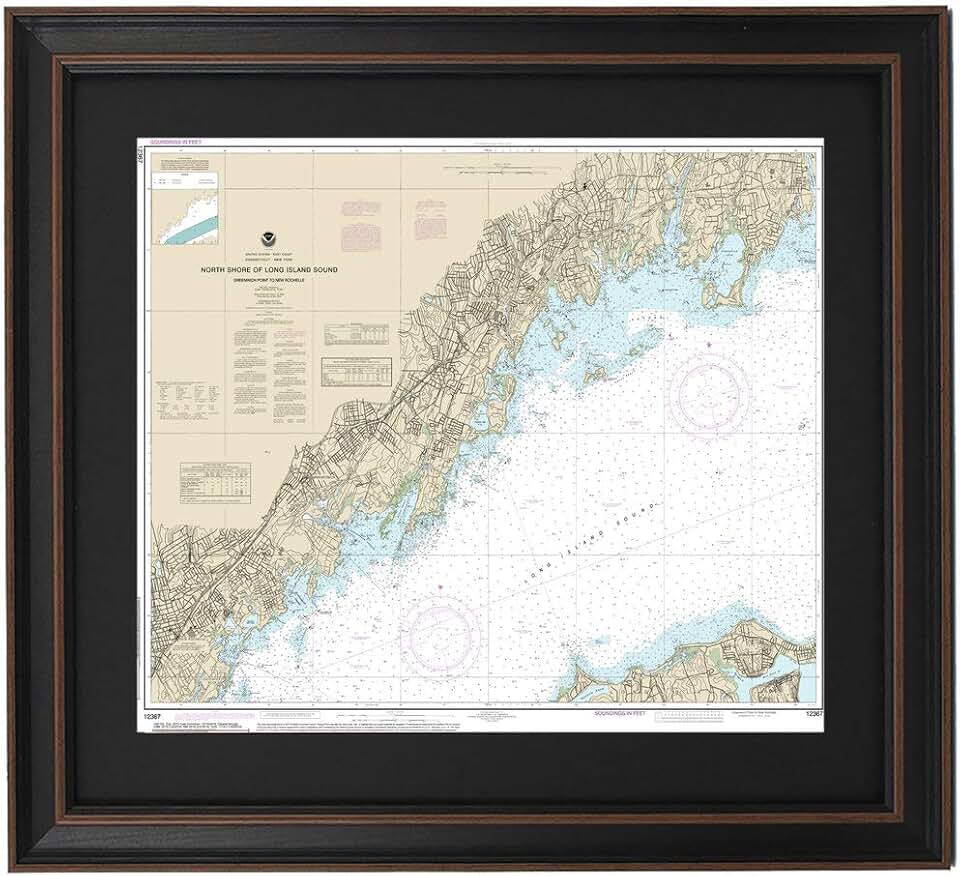
The Framed Nautical Map 12367 offers a captivating glimpse into the rich maritime history and geography of the North Shore of Long Island Sound. This meticulously crafted piece of wall art, handmade in the USA, transforms a functional navigational chart into a beautiful decorative accent for any home or office. It’s more than just a map; it’s a statement piece that speaks to a love for the sea, history, and fine craftsmanship.
Quick Summary: Framed Nautical Map 12367
Rating: Not yet rated (0.0/5.0)
Price: $169.99 USD
Key Pros:
- Authentic and detailed nautical chart design.
- High-quality, handmade craftsmanship in the USA.
- Comes professionally framed and ready to hang.
Key Cons:
- Niche aesthetic may not appeal to all interior styles.
- Premium price point compared to mass-produced decor.
Table of Contents
Framed Nautical Map 12367 Overview
The Framed Nautical Map 12367 is a distinctive piece of art that brings the intricate details of a historical chart into your living space. This particular map focuses on the North Shore of Long Island Sound, specifically charting the area from Greenwich Point to New Rochelle. It’s an ideal acquisition for anyone with an affinity for coastal regions, maritime history, or unique home decor.
What sets this product apart is its commitment to authenticity and quality craftsmanship. Unlike mass-produced prints, each Framed Nautical Map 12367 is handmade in the USA, ensuring attention to detail and a level of care that resonates with discerning buyers. The map itself is a reproduction of an official nautical chart, offering a precise and historically accurate depiction of the coastline, depths, and navigational markers.
The visual appeal of this framed map lies in its blend of technical information and artistic presentation. Nautical charts, with their specific symbology, contour lines, and place names, possess an inherent beauty that transcends their practical purpose. When expertly framed, as this one is, they become compelling visual narratives that invite closer inspection and contemplation.
For those who have a personal connection to the Long Island Sound region, perhaps through sailing, fishing, or simply living near its shores, this map offers a tangible link to cherished memories and experiences. It can serve as a conversation starter, evoking stories of maritime adventures or quiet days spent by the water. The detailed cartography provides endless points of interest for exploration.
The choice of Greenwich Point to New Rochelle as the featured area is significant, encompassing a vibrant and historically rich stretch of the Long Island Sound. This segment is known for its picturesque harbors, yacht clubs, and residential communities, making the map particularly relevant to residents and visitors of these locales. It captures the essence of a specific, beloved geographic region.
Beyond its aesthetic and sentimental value, the Framed Nautical Map 12367 also represents a commitment to supporting local artisans and American manufacturing. The ‘Handmade in USA’ label is a testament to the quality and ethical production standards behind each piece. This aspect adds another layer of value, appealing to consumers who prioritize domestically produced goods.
The standard size of the map ensures it can fit comfortably in various settings, from a cozy study to a spacious living room or a professional office. Its presence can elevate the decor, adding a touch of sophistication and a narrative element that other wall art might lack. It’s a timeless piece that won’t go out of style, much like the enduring allure of the sea itself.
Ultimately, this framed map is designed for individuals who appreciate the confluence of art, geography, and history. It’s a celebration of the Long Island Sound, presented in a format that is both informative and exquisitely decorative. The investment in such a piece is an investment in quality, heritage, and a unique aesthetic.
Framed Nautical Map 12367 Key Features and Specifications
The Framed Nautical Map 12367 stands out due to several key attributes that contribute to its appeal and quality. Understanding these features helps in appreciating the value and craftsmanship embedded in this unique piece of wall art. Each element is carefully considered to deliver a premium product to the customer.
One of the foremost features is the specific geographical coverage. This map meticulously details the North Shore of Long Island Sound, spanning the area from Greenwich Point to New Rochelle. This precise charting ensures that individuals with a connection to this particular stretch of coastline will find it especially meaningful and accurate. It’s not a generic map but a focused geographical representation.
The product is proudly Handmade in USA. This designation signifies a commitment to quality control, skilled artistry, and ethical production practices. The handmade nature often translates to a higher standard of finish and durability compared to mass-produced alternatives. It supports local economies and ensures a unique touch in every piece.
The map arrives professionally framed, ready to hang immediately upon receipt. This convenience eliminates the need for additional expenses or effort in finding a suitable frame and having it mounted. The framing protects the map from environmental damage, such as dust and humidity, preserving its intricate details for years to come.
While specific frame materials are not detailed, professional framing typically involves high-quality wood or composite materials, often with a protective acrylic or glass front. The choice of frame style is usually selected to complement the vintage or classic aesthetic of nautical charts, enhancing its decorative value. The framing adds to the overall perceived quality and longevity of the item.
The base material of the map itself is crucial for its longevity and visual integrity. High-quality paper or archival-grade printing is generally used for such reproductions, ensuring that the colors remain vibrant and the fine lines of the chart stay crisp over time. This prevents fading and degradation, which can be common with lower-quality prints.
As a ‘Standard Size’ item, the dimensions are designed to be versatile for various wall spaces. While exact dimensions are not provided, standard framed art pieces typically range from 18×24 inches to 24×36 inches. This allows it to be a focal point without overwhelming a room, or to be part of a larger gallery wall arrangement. The size is manageable for shipping and handling.
The authenticity of the nautical chart data is a critical feature. These maps are based on official hydrographic surveys, likely from organizations like the NOAA (National Oceanic and Atmospheric Administration). This means the depths, landforms, navigation aids, and other maritime information are accurate representations of the area at the time of charting, offering both aesthetic and educational value.
The intricate details on the map include depth soundings, navigational buoys, lighthouses, coastal features, and even specific place names along the shore. These elements transform the map into a rich tapestry of information, inviting viewers to explore and discover new aspects each time they look at it. It’s a piece that rewards repeated viewing.
The aesthetic is inherently classic and timeless, appealing to a broad range of interior design styles, particularly coastal, traditional, or even minimalist themes seeking a touch of historical character. The muted tones typical of nautical charts, often blues, greens, and browns, make it easy to integrate into existing color schemes. The artwork has a strong sense of heritage and provenance.
In summary, the Framed Nautical Map 12367 offers a combination of precise geographical representation, superior handmade quality, professional presentation, and historical authenticity. These specifications ensure that it is not just a decorative item but a durable, meaningful, and well-crafted piece of art that will be cherished for many years. It is an investment in both beauty and an appreciation for maritime heritage.
Pros & Cons
Every product has its strengths and weaknesses, and the Framed Nautical Map 12367 is no exception. While it offers significant advantages, it’s important for potential buyers to consider both sides before making a purchase decision. Weighing these factors helps in determining if this particular piece of art aligns with individual preferences and expectations.
Pros of the Framed Nautical Map 12367
- Authentic and Detailed Nautical Chart Design: The map is a faithful reproduction of an official nautical chart, offering accurate and intricate details of the North Shore of Long Island Sound. This authenticity is a major draw for maritime enthusiasts and those who appreciate geographical precision. It’s an educational piece as much as it is decorative.
- High-Quality, Handmade Craftsmanship in the USA: The ‘Handmade in USA’ label indicates superior quality and attention to detail. This often means better materials, careful assembly, and a more durable product than mass-produced alternatives. It also supports local artisans and domestic manufacturing.
- Comes Professionally Framed and Ready to Hang: The convenience of receiving a pre-framed piece cannot be overstated. It saves the buyer time, effort, and additional cost associated with custom framing. The professional framing also ensures the map is well-protected and presented in an aesthetically pleasing manner, ready for immediate display.
- Unique and Distinctive Wall Art: Unlike generic prints or posters, a nautical map offers a unique aesthetic that stands out. It’s a conversation starter and reflects a sophisticated taste for history, geography, and maritime culture. It adds character and a personalized touch to any room.
- Historical and Sentimental Value: For individuals with personal ties to the Long Island Sound area, this map holds significant sentimental value. It can evoke memories of trips, homes, or family history, making it more than just decor but a cherished keepsake. The historical nature of the chart adds to its allure.
- Timeless Aesthetic Appeal: Nautical charts have a classic, enduring appeal that transcends fleeting trends. Their visual language, often characterized by muted colors and intricate lines, integrates well into various decor styles, from traditional to contemporary, ensuring it remains a stylish addition for years.
Cons of the Framed Nautical Map 12367
- Niche Aesthetic May Not Appeal to All Interior Styles: While unique, the specific nautical theme and style of the map might not blend seamlessly with every home decor. Individuals who prefer modern minimalist, bohemian, or highly contemporary styles might find it challenging to incorporate this traditional piece. Its appeal is somewhat specialized.
- Premium Price Point Compared to Mass-Produced Decor: At $169.99, this framed map is an investment. While justified by its handmade quality, authenticity, and professional framing, it is more expensive than many standard wall prints or posters available on the market. Budget-conscious buyers might find this a deterrent.
- Limited Geographical Scope: The map covers a very specific section of the Long Island Sound (Greenwich Point to New Rochelle). While this is a pro for those with a connection to this area, it might be a con for individuals looking for a broader overview of the Sound or a different coastal region. Its specificity can be both a strength and a limitation.
- No User Reviews or Ratings Available: The absence of customer reviews or ratings means potential buyers cannot rely on collective feedback to gauge satisfaction, durability, or real-world appearance. This lack of social proof can make the purchasing decision more uncertain for some. Buyers must rely solely on product descriptions and images.
- Potential for Specific Color Palette Limitations: Nautical charts typically adhere to a functional, somewhat subdued color palette. While this contributes to their authentic charm, it might not offer the vibrant color pop some individuals seek in wall art. The aesthetic is more about intricate detail and historical accuracy than bold visual impact.
Considering these pros and cons, the Framed Nautical Map 12367 is clearly designed for a specific audience. Its strengths lie in its authenticity, craftsmanship, and unique charm, while its limitations relate primarily to its niche appeal and price point. For the right buyer, these ‘cons’ are easily outweighed by the significant ‘pros’.
Who Should Buy the Framed Nautical Map 12367?
The Framed Nautical Map 12367 is not just a piece of decor; it’s a statement, a nod to history, and a celebration of a specific locale. Given its unique characteristics, it appeals to a particular demographic. Understanding the ideal buyer helps in recognizing the true value of this exceptional item and ensures it finds its perfect home.
Firstly, this map is an absolute must-have for maritime enthusiasts and nautical history buffs. Anyone with a deep appreciation for sailing, boating, or the historical significance of coastal navigation will find immense joy in owning this authentic chart reproduction. It serves as a visual anchor to their passion, bringing the spirit of the sea indoors.
Secondly, homeowners and residents with a personal connection to the Long Island Sound, particularly the Greenwich Point to New Rochelle area, are prime candidates. This could include those who grew up there, currently reside there, or frequently visit. The map offers a tangible piece of their personal geography, evoking fond memories and a sense of belonging.
Coastal-themed interior decorators and individuals furnishing a beach house or waterfront property will find this map invaluable. Its classic nautical aesthetic perfectly complements seaside decor, adding an authentic and sophisticated touch that elevates the entire design scheme. It provides a focal point that ties the room together with its natural surroundings.
Furthermore, gift-givers looking for a unique and thoughtful present will find the Framed Nautical Map 12367 to be an excellent choice. It’s ideal for birthdays, anniversaries, housewarmings, or retirements, especially for someone who loves the ocean, has a boat, or cherishes memories associated with the Long Island Sound. It’s a gift that speaks volumes about thoughtfulness.
Collectors of unique maps or historical artifacts might also be drawn to this piece. Its handmade quality and specific geographical focus make it a distinct item that stands apart from mass-produced prints. The fact that it’s a reproduction of an official chart adds to its collectibility and historical interest.
Individuals who prioritize supporting American craftsmanship and handmade goods will appreciate that this map is ‘Handmade in USA’. This commitment to local production resonates with consumers who value quality, ethical manufacturing, and the preservation of skilled trades. It’s an investment in a product made with care and integrity.
Finally, anyone seeking to add a touch of sophistication and intellectual curiosity to their living or working space could consider this map. It’s more than just a picture; it’s a detailed representation of an actual place, inviting contemplation and discussion. It elevates the aesthetic of a study, office, or library, making it a focal point of erudition.
While the premium price point might deter some, those who value authenticity, craftsmanship, and a deep connection to the subject matter will find the investment worthwhile. It’s for the discerning buyer who seeks quality and meaning in their decor, rather than just filling a wall. The Framed Nautical Map 12367 is an investment in art, history, and personal connection.
In essence, the ideal buyer for the Framed Nautical Map 12367 is someone who sees beyond mere decoration. They see a story, a history, and a piece of their world beautifully rendered. It’s for those who appreciate the blend of artistic presentation with geographical accuracy and the enduring allure of the sea. This map isn’t just purchased; it’s chosen, for its character and its capacity to inspire.
FAQ about Framed Nautical Map 12367
To help potential buyers make an informed decision, here are answers to some frequently asked questions about the Framed Nautical Map 12367. These insights cover various aspects from its origin to its care, ensuring clarity and confidence in your purchase.
Q1: What specific area does the Framed Nautical Map 12367 depict?
A1: The Framed Nautical Map 12367 specifically details the North Shore of Long Island Sound, covering the stretch from Greenwich Point to New Rochelle. This precise geographical focus makes it particularly relevant for individuals with a connection to these specific coastal communities and waterways. It offers an incredibly detailed view of this particular region.
The map includes various navigational aids, depth soundings, and land features pertinent to this section of the Sound. It’s a snapshot of the maritime landscape, perfect for those who enjoy exploring local geography. The chart provides a historical perspective of the area, making it both beautiful and informative.
Q2: Is the map a genuine historical chart or a modern reproduction?
A2: The Framed Nautical Map 12367 is a high-quality reproduction of an official nautical chart. While it faithfully replicates the style and data of historical charts, it is printed using modern techniques to ensure clarity, durability, and archival quality. This means you get the authentic look without the fragility of an actual antique document.
The use of modern printing also ensures that the colors remain stable over time and the fine details are crisp and legible. It captures the essence of historical cartography while benefiting from contemporary production standards. This blend makes it a robust and visually stunning piece of art.
Q3: What does ‘Handmade in USA’ imply for this product?
A3: ‘Handmade in USA’ signifies that the Framed Nautical Map 12367 is produced with meticulous care and craftsmanship within the United States. This typically involves skilled artisans assembling the map and frame, ensuring a higher standard of quality control and attention to detail than mass-produced items. It supports domestic industries and skilled labor.
This designation also often means that premium materials are used, contributing to the overall durability and aesthetic appeal of the product. The handmade nature adds a unique touch, making each piece subtly distinct and reflecting a commitment to excellence. It’s a testament to the artisan’s dedication.
Q4: Does the map come ready to hang, or do I need to purchase a frame separately?
A4: Yes, the Framed Nautical Map 12367 comes professionally framed and is ready to hang straight out of the box. This convenience is a significant benefit, as it saves you the time, effort, and additional cost of acquiring a suitable frame and having the map mounted. It’s designed for immediate display.
The professional framing also ensures that the map is properly protected from dust, moisture, and potential damage, preserving its condition for many years. The frame itself is chosen to complement the style of the nautical chart, enhancing its overall decorative impact and integration into your decor.
Q5: What kind of material is the map printed on, and what is the frame made of?
A5: While specific materials are not explicitly listed, high-quality framed maps of this caliber are typically printed on premium, archival-grade paper. This ensures long-lasting color vibrancy and sharp detail without fading over time. The paper is usually acid-free to prevent yellowing and degradation.
For the frame, it is generally constructed from durable materials such as solid wood or high-quality composite. A protective cover, usually acrylic or glass, is used to shield the map. These materials are chosen for their aesthetic appeal, durability, and ability to protect the artwork effectively, providing a robust and attractive presentation.
Q6: Is this map suitable for outdoor display?
A6: No, the Framed Nautical Map 12367 is designed exclusively for indoor display. Exposure to outdoor elements such as direct sunlight, rain, humidity, and extreme temperature fluctuations can severely damage the map and its frame. The materials used, particularly the paper and the frame finish, are not weatherproof.
To ensure the longevity and preservation of your map, it should be kept in a climate-controlled indoor environment. This will protect the integrity of the print and the frame, allowing you to enjoy its beauty for many years to come. Direct sunlight, even indoors, can cause fading over time, so placement away from harsh light is recommended.
Q7: How accurate is the nautical information on the map?
A7: The Framed Nautical Map 12367 is based on official nautical charts, which means the information presented is historically accurate for the period it represents. These charts are derived from hydrographic surveys conducted by authoritative bodies like the NOAA or similar agencies. Therefore, the depths, navigational markers, and coastal features are depicted with a high degree of precision.
It’s important to remember that while historically accurate, this reproduction is primarily for decorative purposes and should not be used for active navigation. Modern charts are continuously updated, but for aesthetic and educational value, this map offers an authentic and reliable historical representation of the Long Island Sound’s North Shore. It’s a wonderful tool for armchair exploration.
Final Verdict
The Framed Nautical Map 12367 is an exceptional piece of wall art that beautifully marries historical cartography with quality craftsmanship. It transcends simple decor, offering a window into the rich maritime heritage of the North Shore of Long Island Sound. For the right buyer, its value extends far beyond its aesthetic appeal, touching upon personal connection, educational interest, and a love for the sea.
Its primary strengths lie in its authenticity as a reproduction of an official nautical chart, its meticulous handmade quality in the USA, and the sheer convenience of receiving it professionally framed and ready to hang. These attributes ensure a product that is not only visually stunning but also durable and thoughtfully produced. It’s an investment in a piece that will endure.
While the map’s niche aesthetic and premium price point might not resonate with everyone, these considerations are easily outweighed by its unique charm for those who appreciate its specific appeal. It’s particularly suited for maritime enthusiasts, residents of the Long Island Sound area, or anyone seeking to infuse their home with a sophisticated, coastal, or historical theme. The sentiment it evokes is powerful.
This framed map serves as a fantastic conversation starter, inviting guests to explore its intricate details and learn about the geography it depicts. It’s a piece that offers new discoveries with each glance, making it a dynamic and engaging addition to any room. It fosters a sense of wonder and connection to the vastness of the ocean.
For gift-givers, the Framed Nautical Map 12367 represents a thoughtful and distinctive choice that is likely to be cherished for years. It speaks to a deeper understanding of the recipient’s interests and passions, making it a memorable present for various occasions. It avoids the common pitfalls of generic gifts by being highly specific and meaningful.
In conclusion, if you are seeking a high-quality, authentic, and beautifully presented piece of wall art that celebrates the North Shore of Long Island Sound, the Framed Nautical Map 12367 is an outstanding choice. It’s more than just a map; it’s a piece of history, a work of art, and a tribute to the enduring allure of the ocean. It truly delivers an amazing quality experience.